In 2017, Auckland Airport handled over 19 million passengers, and it is expecting this number to rise to over 40 million annually by 2044.
To cope with the increase in passenger load, the company has embarked on a passenger-flow and road-traffic measurement project, with the aim of obtaining a real-time cohesive view of people movement patterns, to guide daily and long-term operational decisions, maximise capacity and improve flow.
To manage both passenger and traffic flow Auckland Airport has realised the need for a bird’s-eye view of the entire system, as well as detailed, up-close analysis of ongoing issues.
The airport already had access to intelligence on passenger movement inside the terminals, thanks to the use of BlipTrack’s solution, but up until now it had no real-time intelligence on the road network to and from the airport.
With several traffic monitoring projects in New Zealand, using the same technology, infrastructure consultancy company Beca was commissioned to extend the solution across the airport’s road infrastructure. This now provides the airport with a seamless picture of traffic flow information between the airport and Auckland’s city centre.
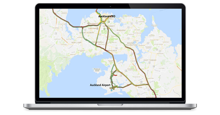
Outside the airport, the solution measures traffic flow between the city centre and the airport, providing real-time data on reliability, vehicle counts and travel time. It provides data about the mix of staff and passengers using Auckland Airport’s Park & Ride facility, enabling it to better understand the performance and regularly review how they can improve their facilities. This information is also analysed to help plan decisions for road network maintenance and infrastructure projects.
The insights, collected using a range of technologies, including radar and Wi-Fi sensors, also helps the New Zealand Traffic Agency (NZTA) make informed traffic management decisions. This has also allowed for the implementation of a number of initiatives, such as optimising traffic signal timings, and combined with the recent opening of the newly constructed Waterview connection, has resulted in significant travel time cuts to and from the airport from the city centre and West Auckland.
Additionally, the real-time and historic BlipTrack data enables NZTA, via its new app RideMate and online, to display live travel times between the city centre and airport, as well as informing about days with a high risk of congestion. This enables road users to plan ahead, reducing both the risk of travellers missing their flights, and airport employees coming in late for work.
Besides the benefits of real-time reporting, the historical data is used to detect driving time anomalies. Therefore, the solution can pinpoint road sections and intersections where driving times deviate from the norm as a result of construction projects, incidents, roadwork, faulty traffic lights and other factors.
Mark Croudace, Manager – Operations at Auckland Airport, said: “The data has provided valuable insight into our operational performance across both our assets and processes. Most importantly, it has enabled us to have meaningful conversations with our key operational stakeholders and vendors, as we collectively seek to improve the passenger experience.”