Zurich Airport has partnered with Google to activate the new Live View feature in the Google Maps app to simplify navigation.
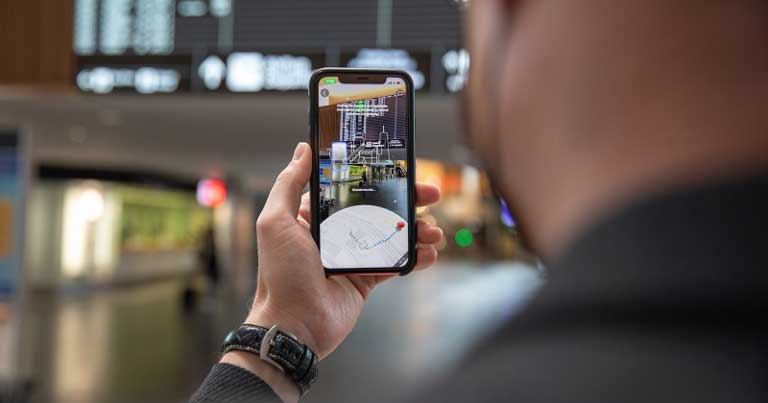
Google Maps Live View uses augmented reality (AR) to provide directions on the passengers’ smartphone camera screen and help them reach their chosen destination at the airport.
Powered by global localisation technology, Live View can help users find the nearest lift, escalators, the right gate, the platform, baggage claim areas, check-in or ticket counters, ATMs and shops. Arrows and accompanying directions point them the right way.
Stefan Gross, Chief Commercial Officer, Flughafen Zürich, commented: “Google Maps Live View is a valuable aid in helping our passengers, who are often not familiar with the airport and also speak a different language, to find their way around Zurich Airport even more easily.”
Petra Ehmann, Global Product Partnership Lead for AR, Google, said: “We welcome the partnership with Flughafen Zürich and are pleased that, together, we have been able to bring Indoor Live View to Zurich as the first airport worldwide. Travellers can use this to navigate intuitively using camera mode.”
The initiative follows a trial implemented in 2018, in which Flughafen Zürich and Google Switzerland launched a project to enhance intuitive navigation ‘from kerb to gate’.
Recordings made of the interior of the airport, as well as exterior areas of The Circle, are now being used in the Indoor Live View function of Google Maps. Using Google Maps Live View, the recordings are compared in the background with the user’s camera images to show the correct route in augmented reality view.
To use Google Maps Live View, users need to launch the Google Maps app, enter their destination and select the “Live View” symbol, which looks like a compass needle. The smartphone camera then opens and the route, plus other key information, is shown directly in camera mode.
New Google Maps functions and navigation are already planned for Zurich Airport in 2022.